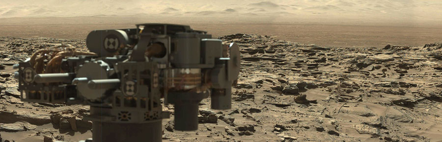
It has now been just more than 2,000 days since NASA’s Curiosity rover landed on the surface of Mars. In the days (or “sols,” as they are called on Mars) since its complex sky-crane touchdown, Curiosity has made countless discoveries with multiple instruments, including drills, lasers, and an array of imaging instruments that so far have sent 468,926 images back to Earth. Gathered here are a few images of Mars from Curiosity over the past few years.
HINTS:View this page full screen. Skip to the next and previous photo by typing j/k or ←/→.
A selfie on Mars, taken by NASA's Mars rover, Curiosity, on January 23, 2018, or Sol 1943, using its Mars Hand Lens Imager. Image stitched together from a series of panoramic images; sky artificially extended. #
NASA / JPL-Caltech / MSSS
[caption id="attachment_20479" align="alignnone" width="586"] Two sizes of wind-sculpted ripples are evident in this view of the top surface of a Martian sand dune. Sand dunes and the smaller type of ripples also exist on Earth. The larger ripples -- roughly 10 feet (3 meters) apart -- are a type not seen on Earth nor previously recognized as a distinct type on Mars. The Mast Camera (Mastcam) on NASA's Curiosity Mars rover took the multiple component images of this scene on Dec. 13, 2015, during the 1,192nd Martian day, or sol, of the rover's work on Mars. That month, Curiosity was conducting the first close-up investigation ever made of active sand dunes anywhere other than Earth. The larger ripples have distinctive sinuous crest lines, compared to the smaller ripples. The location is part of "Namib Dune" in the Bagnold Dune Field, which forms a dark band along the northwestern flank of Mount Sharp. The component images were taken in early morning at this site, with the camera looking in the direction of the sun. This mosaic combining the images has been processed to brighten it and make the ripples more visible. The sand is very dark, both from the morning shadows and from the intrinsic darkness of the minerals that dominate its composition. (NASA/JPL-Caltech/MSSS)[/caption]
Two sizes of wind-sculpted ripples are evident in this view of the top surface of a Martian sand dune. Sand dunes and the smaller type of ripples also exist on Earth. The larger ripples—roughly 10 feet (three meters) apart—are a type not seen on Earth nor previously recognized as a distinct type on Mars. The mast camera (mastcam) on NASA's Curiosity rover took the multiple component images of this scene on December 13, 2015, during the 1,192nd Martian day of the rover's work on Mars.The location is part of Namib Dune in the Bagnold Dune Field, which forms a dark band along the northwestern flank of Mount Sharp. #
JPL-Caltech / MSSS / NASA
[caption id="attachment_20500" align="alignnone" width="512"] This image was taken by Mastcam: Left (MAST_LEFT) onboard NASA's Mars rover Curiosity on Sol 1648, 2017-03-26. (NASA/JPL-Caltech/MSSS)[/caption]
This image was taken by Curiosity's mastcam on Sol 1648, or March 26, 2017. #
JPL-Caltech / MSSS / NASA
[caption id="attachment_20480" align="alignnone" width="660"] NASA's Curiosity Mars rover is seen at the site from which it reached down to drill into a rock target called 'Buckskin' on lower Mount Sharp in this low-angle self-portrait taken August 5, 2015 and released August 19, 2015. The selfie combines several component images taken by Curiosity's Mars Hand Lens Imager (MAHLI) during the 1,065th Martian day, or sol, of the rover's work on Mars, according to a NASA news release. REUTERS/NASA/JPL-Caltech/MSSS/Handout THIS IMAGE HAS BEEN SUPPLIED BY A THIRD PARTY. IT IS DISTRIBUTED, EXACTLY AS RECEIVED BY REUTERS, AS A SERVICE TO CLIENTS. FOR EDITORIAL USE ONLY. NOT FOR SALE FOR MARKETING OR ADVERTISING CAMPAIGNS - TM3EB8J17BD01[/caption]
Curiosity pauses at the site from which it reached down to drill into a rock target called "Buckskin" on lower Mount Sharp in this low-angle self-portrait taken August 5, 2015, and released August 19, 2015. The selfie combines several component images taken by Curiosity's Mars Hand Lens Imager (MAHLI) during the 1,065th Martian day of the rover's work on Mars. #
NASA / Reuters
Curiosity recorded this view of the sun setting at the close of the mission's 956th Martian day, on April 15, 2015, from the rover's location in Gale Crater, Mars. #
JPL-Caltech / MSSS / Texas A&M Univ via Getty / NASA / Getty
On September 9, 2012, when it was just starting out, a close view of two of the left wheels of Curiosity. In the distance is the lower slope of Mount Sharp. #
JPL-Caltech / Malin Space Science Systems / NASA / Reuters
[caption id="attachment_20482" align="alignnone" width="688"] A NASA handout photo shows the three left wheels of NASA's Mars rover Curiosity combined in two images that were taken by the rover's Mars Hand Lens Imager (MAHLI) on September 9, 2012. In the distance is the lower slope of Mount Sharp. REUTERS/NASA/JPL-Caltech/Malin Space Science Systems/Handout (UNITED STATES - Tags: SCIENCE TECHNOLOGY) THIS IMAGE HAS BEEN SUPPLIED BY A THIRD PARTY. IT IS DISTRIBUTED, EXACTLY AS RECEIVED BY REUTERS, AS A SERVICE TO CLIENTS. FOR EDITORIAL USE ONLY. NOT FOR SALE FOR MARKETING OR ADVERTISING CAMPAIGNS - TM3E89A0WFB01[/caption]
Years later, on April 18, 2016, NASA used the MAHLI camera to check the condition of the wheels once again. This image of Curiosity's left-middle and left-rear wheels is part of an inspection set taken during Sol 1,315. Holes and tears in the wheels worsened significantly during 2013 as Curiosity was crossing terrain studded with sharp rocks on its route near its 2012 landing site to the base of Mount Sharp. Team members are keeping a close eye for when any of the zig-zag-shaped treads, call grousers, begin to break. Longevity testing with identical wheels on Earth indicates that when three grousers on a given wheel have broken, that wheel has reached about 60 percent of its useful mileage. Curiosity's six aluminum wheels are about 20 inches (50 centimeters) in diameter and 16 inches (40 centimeters) wide. Each of the six wheels has its own drive motor, and the four corner wheels also have steering motors. #
JPL-Caltech / MSSS / NASA
[caption id="attachment_20484" align="alignnone" width="785"] NASA's Curiosity Mars rover used the Navigation Camera (Navcam) on its mast for this look back after finishing a drive of 328 feet (100 meters) on the 548th Martian day, or sol, of the rover's work on Mars (Feb. 19, 2014). The rows of rocks just to the right of the fresh wheel tracks in this view are an outcrop called "Junda." The rows form striations on the ground, a characteristic seen in some images of this area taken from orbit. A panorama made from Navcam images taken during a pause to observe Junda partway through the Sol 548 drive is available at PIA17947. For scale, the distance between Curiosity's parallel wheel tracks is about 9 feet (2.7 meters). This view is looking toward the east-northeast. (NASA/JPL-Caltech)[/caption]
NASA's Curiosity Mars rover used the navcam on its mast for this look back after finishing a drive of 328 feet (100 meters) on Sol 548 (February 19, 2014). The rows of rocks just to the right of the fresh wheel tracks in this view are an outcrop called "Junda." The rows form striations on the ground, a characteristic seen in some images of this area taken from orbit. For scale, the distance between Curiosity's parallel wheel tracks is about 9 feet (2.7 meters). #
JPL-Caltech / NASA
This view from NASA's Curiosity Mars Rover shows the downwind side of Namib Dune, which stands about 13 feet (4 meters) high. The site is part of Bagnold Dunes, a band of dark sand dunes along the northwestern flank of Mars's Mount Sharp. The component images stitched together into this scene were taken with Curiosity's navcam on December 17, 2015, during Sol 1196. #
JPL-Caltech / NASA
[caption id="attachment_20486" align="alignnone" width="753"] The dark, smooth-surfaced object at the center of this Oct. 30, 2016, image from the Mast Camera (Mastcam) on NASA's Curiosity Mars rover was examined with laser pulses and confirmed to be an iron-nickel meteorite. The grid of shiny points visible on the object resulted from that laser zapping by Curiosity's Chemistry and Camera (ChemCam) instrument. The meteorite is about the size of a golf ball. It is informally named "Egg Rock," for a site in Maine. Locations around Bar Harbor, Maine, are the naming theme for an area on Mars' Mount Sharp that Curiosity reached in October. Iron-nickel meteorites are a common class of space rocks found on Earth, and previous examples have been found on Mars, but Egg Rock is the first on Mars to be examined with a laser-firing spectrometer. The scene is presented with a color adjustment that approximates white balancing, to resemble how the rocks and sand would appear under daytime lighting conditions on Earth. Figure 1 includes a scale bar of 5 centimeters (about 2 inches). (NASA/JPL-Caltech/MSSS)[/caption]
The dark, smooth-surfaced object at the center of this October 30, 2016, image from the mastcam on Curiosity was examined with laser pulses and confirmed to be an iron-nickel meteorite. The grid of shiny points visible on the object resulted from that laser zapping by Curiosity's Chemistry and Camera (ChemCam) instrument. The meteorite is about the size of a golf ball. It is informally named "Egg Rock," after a site in Maine. Locations around Bar Harbor, Maine, are the naming theme for an area on Mars' Mount Sharp that Curiosity reached in October. Iron-nickel meteorites are a common class of space rocks found on Earth, and previous examples have been found on Mars, but Egg Rock is the first on Mars to be examined with a laser-firing spectrometer. The scene is presented with a color adjustment that approximates white balancing, to resemble how the rocks and sand would appear under daytime lighting conditions on Earth. Figure one includes a scale bar of five centimeters (about two inches). #
[caption id="attachment_20487" align="alignnone" width="714"] This view from the Mast Camera (Mastcam) in NASA's Curiosity Mars rover shows a hillside outcrop with layered rocks within the "Murray Buttes" region on lower Mount Sharp. The buttes and mesas rising above the surface in this area are eroded remnants of ancient sandstone that originated when winds deposited sand after lower Mount Sharp had formed. Curiosity closely examined that layer -- called the "Stimson formation" -- during the first half of 2016, while crossing a feature called "Naukluft Plateau" between two exposures of the Murray formation. The layering within the sandstone is called "cross-bedding" and indicates that the sandstone was deposited by wind as migrating sand dunes. The image was taken on Sept. 8, 2016, during the 1454th Martian day, or sol, of Curiosity's work on Mars. (NASA/JPL-Caltech/MSSS)[/caption]
JPL-Caltech / MSSS / NASA
This view from the Mastcam shows a hillside outcrop with layered rocks within the Murray Buttes region on lower Mount Sharp. The buttes and mesas rising above the surface in this area are eroded remnants of ancient sandstone that originated when winds deposited sand after lower Mount Sharp had formed. Curiosity closely examined that layer—called the "Stimson formation"—during the first half of 2016, while crossing a feature called "Naukluft Plateau" between two exposures of the Murray formation. The layering within the sandstone is called "cross-bedding," and indicates that the sandstone was deposited by wind as migrating sand dunes. The image was taken on September 8, 2016, during Sol 1454. #
JPL-Caltech / MSSS / NASA
A view of the two moons of Mars comes from a set of images taken by Curiosity as the larger moon, Phobos, passed in front of the smaller one, Deimos, from Curiosity's perspective, on August 1, 2013. Curiosity used the telephoto-lens camera of its two-camera mastcam instrument to catch a series of images of the moons before, during, and after the occultation of Deimos by Phobos. This processed image stacks information from several images of each moon to enhance the visibility of smaller features. The two moons's positions relative to each other are taken from one of the frames from just before the occultation. On Phobos, Stickney Crater is visible on the top. It is on the leading hemisphere of Phobos. Hall Crater, in the south, is the prominent feature on the left hand side. #
JPL-Caltech / Malin Space Science Systems / Texas A&M University / NASA
[caption id="attachment_20489" align="alignnone" width="731"] A view from NASA's Mars Reconnaissance Orbiter on April 8, 2015, catches sight of NASA's Curiosity Mars rover passing through a valley called "Artist's Drive" on the lower slope of Mount Sharp. The image is from the orbiter's High Resolution Imaging Science Experiment (HiRISE) camera. It shows the rover's position after a drive of about 75 feet (23 meters) during the 949th Martian day, or sol, of the rover's work on Mars. North is toward the top. The rover's shadow extends toward the right. The view in this image covers an area about 550 yards (500 meters) across. (NASA/JPL-Caltech/Univ. of Arizona)[/caption]
A view from above. This image from NASA's Mars Reconnaissance Orbiter on April 8, 2015, catches sight of NASA's Curiosity Mars rover passing through a valley called Artist's Drive on the lower slope of Mount Sharp. The image is from the orbiter's High Resolution Imaging Science Experiment (HiRISE) camera. It shows the rover's position after a drive of about 75 feet (23 meters) during Sol 949. North is toward the top, and the rover's shadow extends toward the right. #
JPL-Caltech / Univ. of Arizona / NASA
[caption id="attachment_20490" align="alignnone" width="713"] This dark mound, called "Ireson Hill," rises about 16 feet (5 meters) above redder layered outcrop material of the Murray formation on lower Mount Sharp, Mars, near a location where NASA's Curiosity rover examined a linear sand dune in February 2017. Researchers used the rover's Mast Camera (Mastcam) on Feb. 2, 2017, during the 1,598th Martian day, or sol, of Curiosity's work on Mars, to take the 41 images combined into this scene. The mosaic has been white-balanced so that the colors of the rock and sand materials resemble how they would appear under daytime lighting conditions on Earth. The view extends from west-southwest on the left to north-northwest on the right. The faint horizon in the distance beyond Ireson Hill is part of the rim of Gale Crater. (NASA/JPL-Caltech/MSSS)[/caption]
This dark mound, called "Ireson Hill," rises about 16 feet (5 meters) above redder layered outcrop material of the Murray formation on lower Mount Sharp, Mars, near a location where NASA's Curiosity rover examined a linear sand dune in February 2017. Researchers used the rover's mastcam on February 2, 2017, during Sol 1598 to take the multiple images combined into this scene. The faint horizon in the distance beyond Ireson Hill is part of the rim of Gale Crater. #
JPL-Caltech / MSSS / NASA
[caption id="attachment_20491" align="alignnone" width="759"] The penny in this image is part of a camera calibration target on NASA's Mars rover Curiosity. The Mars Hand Lens Imager (MAHLI) camera on the rover took this and other images of the MAHLI calibration target during the 34th Martian day, or sol, of Curiosity's work on Mars (Sept. 9, 2012). The image was acquired with MAHLI at a distance of 5 centimeters (2 inches). "When a geologist takes pictures of rock outcrops she is studying, she wants an object of known scale in the photographs," said MAHLI Principal Investigator Ken Edgett, of Malin Space Science Systems, San Diego. "If it is a whole cliff face, she'll ask a person to stand in the shot. If it is a view from a meter or so away, she might use a rock hammer. If it is a close-up, as the MAHLI can take, she might pull something small out of her pocket. Like a penny." Edgett bought the special penny that's aboard Curiosity with funds from his own pocket. It is a 1909 "VDB" cent, from the first year Lincoln pennies were minted, the centennial of Abraham Lincoln's birth, with the VDB initials of the coin's designer – Victor David Brenner -- on the reverse. "The penny is on the MAHLI calibration target as a tip of the hat to geologists' informal practice of placing a coin or other object of known scale in their photographs. "Everyone in the United States can recognize the penny and immediately know how big it is, and can compare that with the rover hardware and Mars materials in the same image," Edgett said. "The public can watch for changes in the penny over the long term on Mars. Will it change color? Will it corrode? Will it get pitted by windblown sand?" February of 2012 (NASA/JPL)[/caption]
Two views of a century-old penny on mars. This penny is part of a camera calibration target attached to Curiosity. The MAHLI camera on the rover took this image during Sol 34 (September 9, 2012). "When a geologist takes pictures of rock outcrops she is studying, she wants an object of known scale in the photographs," said MAHLI Principal Investigator Ken Edgett, of Malin Space Science Systems, San Diego. "If it is a whole cliff face, she'll ask a person to stand in the shot. If it is a view from a meter or so away, she might use a rock hammer. If it is a close-up, as the MAHLI can take, she might pull something small out of her pocket. Like a penny." Edgett bought the special penny that's aboard Curiosity with funds from his own pocket. It is a 1909 "VDB" cent from the first year Lincoln pennies were minted, the centennial of Abraham Lincoln's birth, with the VDB initials of the coin's designer—Victor David Brenner—on the reverse. The penny is on the MAHLI calibration target as a tip of the hat to geologists's informal practice of placing a coin or other object of known scale in their photographs. "Everyone in the United States can recognize the penny and immediately know how big it is, and can compare that with the rover hardware and Mars materials in the same image," Edgett said. "The public can watch for changes in the penny over the long term on Mars. Will it change color? Will it corrode? Will it get pitted by windblown sand?" At right, the same penny, re-photographed on December 2, 2017, or Sol 1892, showing almost no visible wear, with only a small coating of dust. #
JPL / NASA
[caption id="attachment_20492" align="alignnone" width="730"] This image from the Navigation Camera on NASA's Curiosity Mars rover shows wheel tracks printed by the rover as it drove on the sandy floor of a lowland called "Hidden Valley" on the route toward Mount Sharp. The image was taken during the 709th Martian day, or sol, of the rover's work on Mars (Aug. 4, 2014). That was one day before the second anniversary, in Earth years, of Curiosity's landing on Mars. (NASA/JPL-Caltech)[/caption]
This image from Curiosity shows wheel tracks printed by the rover as it drove on the sandy floor of a lowland called "Hidden Valley" on the route toward Mount Sharp. The image was taken during the 709th Martian day of the rover's work on Mars (August 4, 2014). #
JPL-Caltech / NASA
[caption id="attachment_20493" align="alignnone" width="784"] A vantage point on "Vera Rubin Ridge" provided NASA's Curiosity Mars rover this detailed look back over the area where it began its mission inside Gale Crater, plus more-distant features of the crater. This view toward the north-northeast combines eight images taken by the right-eye, telephoto-lens camera of Curiosity's Mast Camera (Mastcam). It shows more detail of a fraction of the area pictured in a more sweeping panorama (PIA22210) acquired from the same rover location using Mastcam's left-eye, wider-angle-lens camera. The scene has been white-balanced so the colors of the rock materials resemble how they would appear under daytime lighting conditions on Earth. The component images were taken on Oct. 25, 2017, during the 1,856th Martian day, or sol, of the rover's work on Mars. At that point, Curiosity had gained 1,073 feet (327 meters) in elevation and driven 10.95 miles (17.63 kilometers) from its landing site. Mount Sharp stands about 3 miles (5 kilometers) high in the middle of Gale Crater, which spans 96 miles (154 kilometers) in diameter. Vera Rubin Ridge is on the northwestern flank of lower Mount Sharp. The right foreground of this panorama shows a portion of Vera Rubin Ridge. In the distance is the northern wall of Gale Crater, with the rim crest forming the horizon roughly 25 miles (40 kilometers) from the rover's location. (NASA/JPL-Caltech/MSSS)[/caption]
A vantage point on Vera Rubin Ridge provided Curiosity this detailed look back over the area where it began its mission inside Gale Crater, plus more-distant features of the crater. This view toward the north-northeast combines eight images taken by the right-eye telephoto-lens camera of Curiosity's mastcam. The component images were taken on October 25, 2017, during Sol 1856. At that point, Curiosity had gained 1,073 feet (327 meters) in elevation and driven 10.95 miles (17.63 kilometers) from its landing site. #
JPL-Caltech / MSSS / NASA
[caption id="attachment_20494" align="alignnone" width="736"] This self-portrait of NASA's Curiosity Mars rover shows the vehicle at "Namib Dune," where the rover's activities included scuffing into the dune with a wheel and scooping samples of sand for laboratory analysis. The scene combines 57 images taken on Jan. 19, 2016, during the 1,228th Martian day, or sol, of Curiosity's work on Mars. The camera used for this is the Mars Hand Lens Imager (MAHLI) at the end of the rover's robotic arm. (NASA/JPL-Caltech/MSSS)[/caption]
This self-portrait of NASA's Curiosity Mars rover shows the vehicle at Namib Dune, where the rover's activities included scuffing into the dune with a wheel and scooping samples of sand for laboratory analysis. The scene was taken on January 19, 2016, during Sol 1228. #
JPL-Caltech / MSSS / NASA
Beyond a dark sand dune closer to the rover, a Martian dust devil passes in front of the horizon in this sequence of images from Curiosity. The rover's navigation camera made this series of observations on February 4, 2017, in the summertime afternoon of Sol 1599. Set within a broader view centered at south-southwest, the rectangular area outlined in black was imaged multiple times over a span of several minutes to check for dust devils. Images from the period with most activity are shown in the inset area. Contrast has been modified to make frame-to-frame changes easier to see. The images are in pairs that were taken about 12 seconds apart, with an interval of about 90 seconds between pairs. Timing is accelerated and not fully proportional in this animation. On Mars as on Earth, dust devils are whirlwinds that result from sunshine warming the ground, prompting convective rising of air that has gained heat from the ground. Observations of Martian dust devils provide information about wind directions and interaction between the surface and the atmosphere. #
NASA / JPL-Caltech / TAMU
[caption id="attachment_20495" align="alignnone" width="729"] The Mars Hand Lens Imager (MAHLI) camera on the robotic arm of NASA's Curiosity Mars rover used electric lights at night to illuminate this view of Martian sand grains dumped on the ground after sorting with a sieve. The view covers an area roughly 1.1 inches by 0.8 inch (2.8 centimeters by 2.1 centimeters). The grains seen here were too large to pass through a sieve with 150-micron (0.006 inch) pores. They were part of the sand in the first scoop collected by Curiosity at "Namib Dune." A different portion of that scoop -- consisting of grains small enough to pass through the 150-micron sieve -- was delivered to the rover's on-board laboratory instruments for analysis. The larger-grain portion dumped onto the ground became accessible to investigation by other instruments on Curiosity, including imaging by MAHLI and composition analysis by the Chemistry and Camera (ChemCam) and Alpha Particle X-ray Spectrometer instruments. Laser-zapping of the dump pile by ChemCam caused an elongated dimple visible near the center of this view. The MAHLI images combined into this focus-merged view were taken on Jan. 22, 2016, after dark on the 1,230th Martian day, or sol, of Curiosity's work on Mars. The illumination source is two white-light LEDs (light-emitting diodes) on MAHLI. They shone down on the right side of the image, so shadows are toward the left. The focus-merge product was generated by the instrument autonomously combining in-focus portions of eight separate images taken at different focus settings. The dark appearance is purposeful: The camera team chose an exposure setting that would prevent most of the white grains in this otherwise very dark sand from being over-exposed. (NASA/JPL-Caltech/MSSS)[/caption]
The Mars Hand Lens Imager camera on the robotic arm of Curiosity used electric lights at night to illuminate this view of Martian sand grains dumped on the ground after sorting with a sieve. The view covers an area roughly 1.1 inches by 0.8 inch (2.8 centimeters by 2.1 centimeters). The grains seen here were too large to pass through a sieve with 150-micron (0.006 inch) pores. They were part of the sand in the first scoop collected by Curiosity at Namib Dune. A different portion of that scoop—consisting of grains small enough to pass through the 150-micron sieve—was delivered to the rover's on-board laboratory instruments for analysis. The images combined into this focus-merged view were taken on January 22, 2016, after dark on Sol 1230. #
JPL-Caltech / MSSS / NASA
[caption id="attachment_20496" align="alignnone" width="766"] This composite image looking toward the higher regions of Mount Sharp was taken on September 9, 2015, by NASA's Curiosity rover. In the foreground -- about 2 miles (3 kilometers) from the rover -- is a long ridge teeming with hematite, an iron oxide. Just beyond is an undulating plain rich in clay minerals. And just beyond that are a multitude of rounded buttes, all high in sulfate minerals. The changing mineralogy in these layers of Mount Sharp suggests a changing environment in early Mars, though all involve exposure to water billions of years ago. The Curiosity team hopes to be able to explore these diverse areas in the months and years ahead. Further back in the image are striking, light-toned cliffs in rock that may have formed in drier times and now is heavily eroded by winds. The colors are adjusted so that rocks look approximately as they would if they were on Earth, to help geologists interpret the rocks. This "white balancing" to adjust for the lighting on Mars overly compensates for the absence of blue on Mars, making the sky appear light blue and sometimes giving dark, black rocks a blue cast. (NASA/JPL-Caltech/MSSS)[/caption]
This composite image looking toward the higher regions of Mount Sharp was taken on September 9, 2015, by NASA's Curiosity rover. In the foreground, about two miles (three kilometers) from the rover, is a long ridge teeming with hematite, an iron oxide. Just beyond is an undulating plane rich in clay minerals. And just beyond that are a multitude of rounded buttes, all high in sulfate minerals. The changing mineralogy in these layers of Mount Sharp suggests a changing environment in early Mars, though all involve exposure to water billions of years ago. Further back in the image are striking, light-toned cliffs in rock that may have formed in drier times and now are heavily eroded by winds. The colors are adjusted so that rocks look approximately as they would if they were on Earth, to help geologists interpret the rocks. This "white balancing" to adjust for the lighting on Mars overly compensates for the absence of blue on Mars, making the sky appear light blue and sometimes giving dark, black rocks a blue cast. #
JPL-Caltech / MSSS / NASA
[caption id="attachment_20497" align="alignnone" width="714"] This look back at a dune that NASA's Curiosity Mars rover drove across was taken by the rover's Mast Camera (Mastcam) during the 538th Martian day, or sol, of Curiosity's work on Mars (Feb. 9, 2014). The rover had driven over the dune three days earlier. For scale, the distance between the parallel wheel tracks is about 9 feet (2.7 meters). The dune is about 3 feet (1 meter) tall in the middle of its span across an opening called "Dingo Gap." This view is looking eastward. (NASA/JPL-Caltech/MSSS)[/caption]
This look back at a dune that NASA's Curiosity Mars rover drove across was taken by the rover's mastcam during Sol 538, or February 9, 2014. The rover had driven over the dune three days earlier. The dune is about three feet (one meter) tall in the middle of its span across an opening called Dingo Gap. #
JPL-Caltech / MSSS / NASA
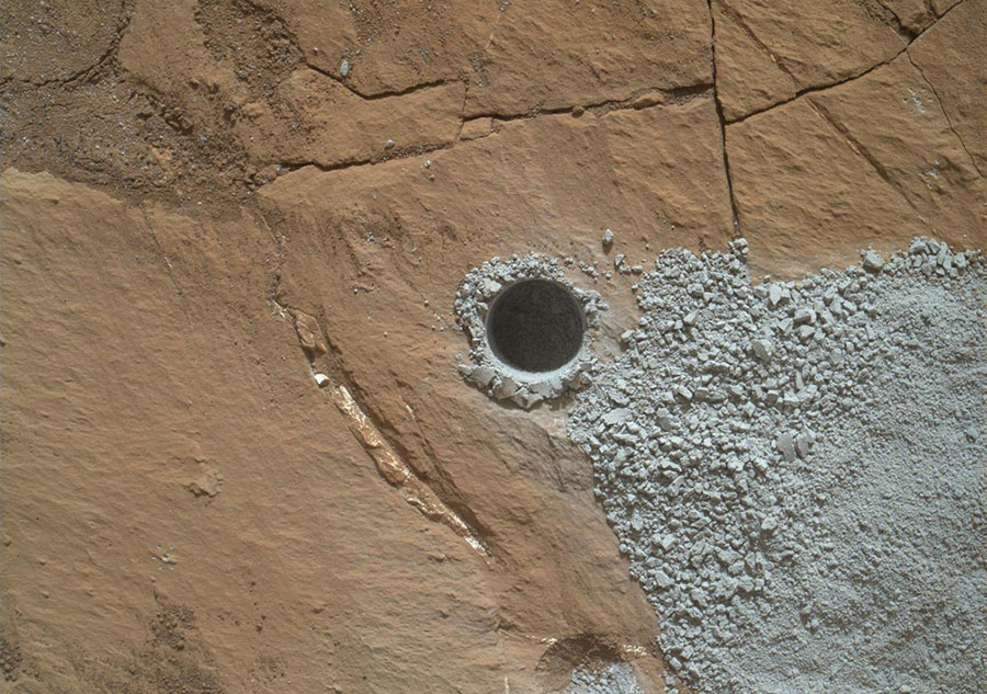
Curiosity drilled this hole to collect sample material from a rock target called Buckskin on July 30, 2015, during Sol 1060. The diameter is slightly smaller than a dime. Rock powder from the collected sample was subsequently delivered to a laboratory inside the rover for analysis. The rover's drill did not experience any sign during this sample collection of an intermittent short-circuiting issue that was detected earlier in 2015. The Buckskin target is in an area near Marias Pass on lower Mount Sharp where Curiosity had detected unusually high levels of silica and hydrogen. #
JPL-Caltech / MSSS / NASA
A panorama of the Martin landscape made from a mosaic of images taken by Curiosity on Sol 1276, or March 9, 2016. #

 Two sizes of wind-sculpted ripples are evident in this view of the top surface of a Martian sand dune. Sand dunes and the smaller type of ripples also exist on Earth. The larger ripples -- roughly 10 feet (3 meters) apart -- are a type not seen on Earth nor previously recognized as a distinct type on Mars.
 This image was taken by Mastcam: Left (MAST_LEFT) onboard NASA's Mars rover Curiosity on Sol 1648, 2017-03-26. (NASA/JPL-Caltech/MSSS)[/caption]
 NASA's Curiosity Mars rover is seen at the site from which it reached down to drill into a rock target called 'Buckskin' on lower Mount Sharp in this low-angle self-portrait taken August 5, 2015 and released August 19, 2015. The selfie combines several component images taken by Curiosity's Mars Hand Lens Imager (MAHLI) during the 1,065th Martian day, or sol, of the rover's work on Mars, according to a NASA news release. REUTERS/NASA/JPL-Caltech/MSSS/Handout THIS IMAGE HAS BEEN SUPPLIED BY A THIRD PARTY. IT IS DISTRIBUTED, EXACTLY AS RECEIVED BY REUTERS, AS A SERVICE TO CLIENTS. FOR EDITORIAL USE ONLY. NOT FOR SALE FOR MARKETING OR ADVERTISING CAMPAIGNS - TM3EB8J17BD01[/caption]

 A NASA handout photo shows the three left wheels of NASA's Mars rover Curiosity combined in two images that were taken by the rover's Mars Hand Lens Imager (MAHLI) on September 9, 2012. In the distance is the lower slope of Mount Sharp. REUTERS/NASA/JPL-Caltech/Malin Space Science Systems/Handout (UNITED STATES - Tags: SCIENCE TECHNOLOGY) THIS IMAGE HAS BEEN SUPPLIED BY A THIRD PARTY. IT IS DISTRIBUTED, EXACTLY AS RECEIVED BY REUTERS, AS A SERVICE TO CLIENTS. FOR EDITORIAL USE ONLY. NOT FOR SALE FOR MARKETING OR ADVERTISING CAMPAIGNS - TM3E89A0WFB01[/caption]
 NASA's Curiosity Mars rover used the Navigation Camera (Navcam) on its mast for this look back after finishing a drive of 328 feet (100 meters) on the 548th Martian day, or sol, of the rover's work on Mars (Feb. 19, 2014). The rows of rocks just to the right of the fresh wheel tracks in this view are an outcrop called "Junda." The rows form striations on the ground, a characteristic seen in some images of this area taken from orbit. A panorama made from Navcam images taken during a pause to observe Junda partway through the Sol 548 drive is available at PIA17947.
 The dark, smooth-surfaced object at the center of this Oct. 30, 2016, image from the Mast Camera (Mastcam) on NASA's Curiosity Mars rover was examined with laser pulses and confirmed to be an iron-nickel meteorite.
 This view from the Mast Camera (Mastcam) in NASA's Curiosity Mars rover shows a hillside outcrop with layered rocks within the "Murray Buttes" region on lower Mount Sharp.
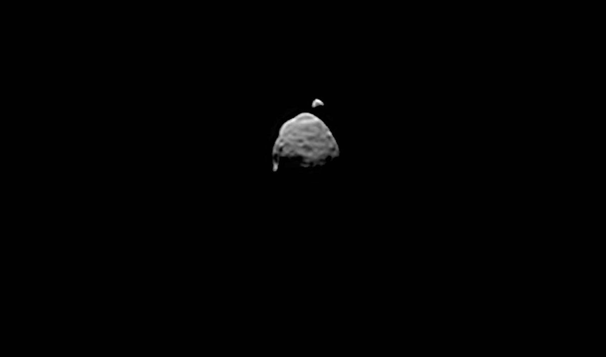
 A view from NASA's Mars Reconnaissance Orbiter on April 8, 2015, catches sight of NASA's Curiosity Mars rover passing through a valley called "Artist's Drive" on the lower slope of Mount Sharp.
 This dark mound, called "Ireson Hill," rises about 16 feet (5 meters) above redder layered outcrop material of the Murray formation on lower Mount Sharp, Mars, near a location where NASA's Curiosity rover examined a linear sand dune in February 2017.
 The penny in this image is part of a camera calibration target on NASA's Mars rover Curiosity. The Mars Hand Lens Imager (MAHLI) camera on the rover took this and other images of the MAHLI calibration target during the 34th Martian day, or sol, of Curiosity's work on Mars (Sept. 9, 2012). The image was acquired with MAHLI at a distance of 5 centimeters (2 inches).
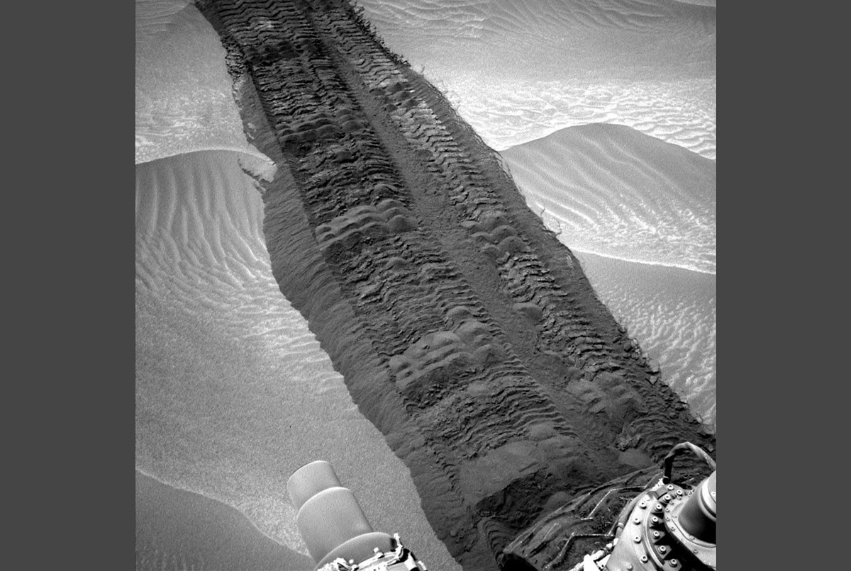 This image from the Navigation Camera on NASA's Curiosity Mars rover shows wheel tracks printed by the rover as it drove on the sandy floor of a lowland called "Hidden Valley" on the route toward Mount Sharp. The image was taken during the 709th Martian day, or sol, of the rover's work on Mars (Aug. 4, 2014). That was one day before the second anniversary, in Earth years, of Curiosity's landing on Mars. (NASA/JPL-Caltech)[/caption]
 A vantage point on "Vera Rubin Ridge" provided NASA's Curiosity Mars rover this detailed look back over the area where it began its mission inside Gale Crater, plus more-distant features of the crater.
 This self-portrait of NASA's Curiosity Mars rover shows the vehicle at "Namib Dune," where the rover's activities included scuffing into the dune with a wheel and scooping samples of sand for laboratory analysis.
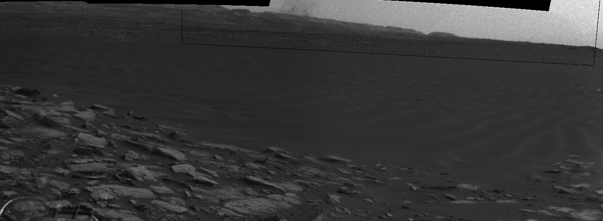
 The Mars Hand Lens Imager (MAHLI) camera on the robotic arm of NASA's Curiosity Mars rover used electric lights at night to illuminate this view of Martian sand grains dumped on the ground after sorting with a sieve.
 This composite image looking toward the higher regions of Mount Sharp was taken on September 9, 2015, by NASA's Curiosity rover. In the foreground -- about 2 miles (3 kilometers) from the rover -- is a long ridge teeming with hematite, an iron oxide. Just beyond is an undulating plain rich in clay minerals. And just beyond that are a multitude of rounded buttes, all high in sulfate minerals. The changing mineralogy in these layers of Mount Sharp suggests a changing environment in early Mars, though all involve exposure to water billions of years ago. The Curiosity team hopes to be able to explore these diverse areas in the months and years ahead. Further back in the image are striking, light-toned cliffs in rock that may have formed in drier times and now is heavily eroded by winds.
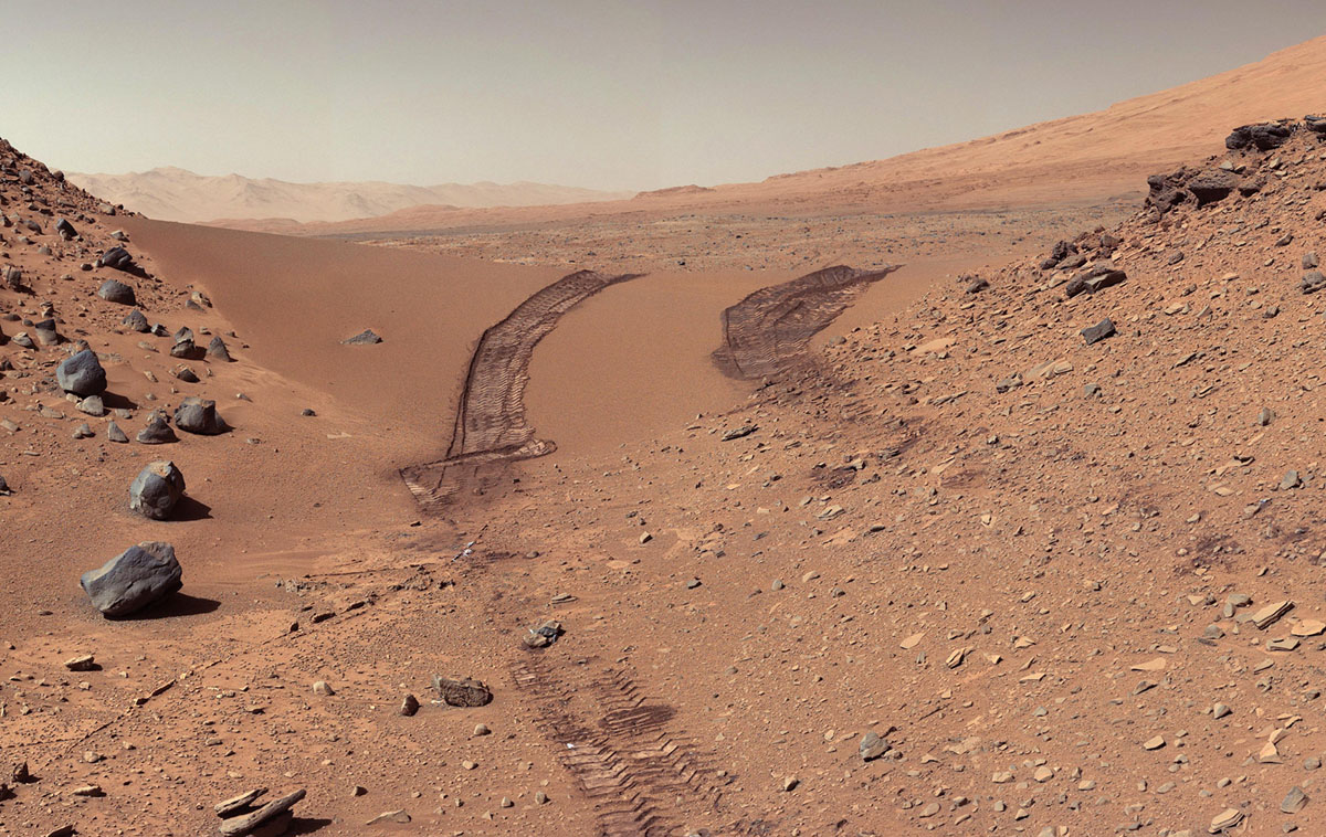 This look back at a dune that NASA's Curiosity Mars rover drove across was taken by the rover's Mast Camera (Mastcam) during the 538th Martian day, or sol, of Curiosity's work on Mars (Feb. 9, 2014). The rover had driven over the dune three days earlier. For scale, the distance between the parallel wheel tracks is about 9 feet (2.7 meters). The dune is about 3 feet (1 meter) tall in the middle of its span across an opening called "Dingo Gap." This view is looking eastward. (NASA/JPL-Caltech/MSSS)[/caption]